


SOLU-KHUMBU (EVEREST) REGION MAP 1:100,000
Quick Overview
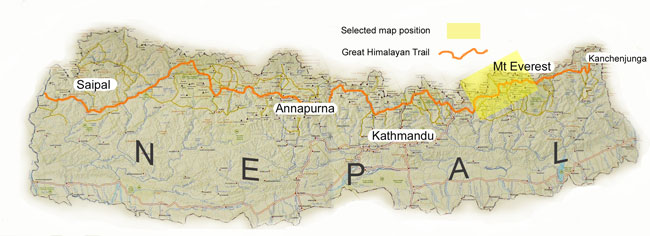
One of a series of maps that cover the Great Himalayan Trail (GHT) in its entirety, this one covers the popular Khumbu region.
Solu Khumbu Everest Region Map
Scale: 1:125,000
One of a series of maps that cover the Great Himalayan Trail (GHT) in its entirety.
This map is printed on a waterproof and tear-resistant paper. The map highlights main trekking routes from Lukla, both north and south of the town: Everest Base Camp Trek, alternative routes to the Gokyo Lakes, Bhote Koshi trek to the Nagpa La pass, Lukla to Makalu Base Camp Trek, and several routes south of the town around Salleri and further eastwards, including Pikey Cultural Trail. Also highlighted are the relevant sections of the GHT Cultural Trail and the GHT High Route. Contours are at 40m intervals. Route profile shows the Solu Khumbu section of the GHT High Route between the Makalu Base Camp and the Glacier Base Camp.
Main trekking routes are prominently highlighted, as are selected settlements along them, indicating where tourist accommodation and other services are provided. Also clearly marked are campsites or base camps and various places of interest. The maps also show other local trekking paths, often providing variants or shortcuts to the main routes. Latitude and longitude coordinates are given as margin ticks at 5’ intervals.
Standard/Free shipping to major capitals takes 2-5 business days (after dispatch), with occasional delays.
Order before 11am - we usually ship the same business day!
Choose Express Post for priority packing and faster shipping.


