


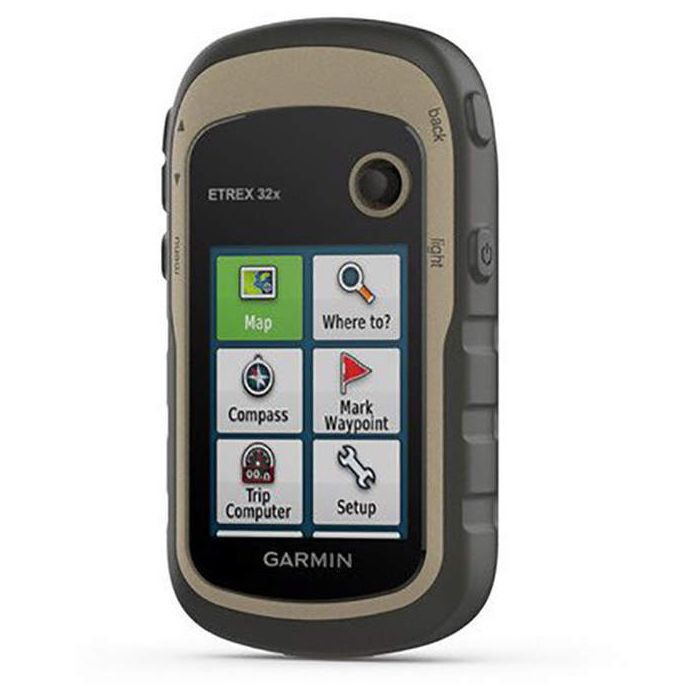
GARMIN eTREX 32x
Quick Overview
Rugged, handheld GPS with compass and barometric altimeter. Durable and water-resistant.
Rugged, handheld GPS with compass and barometric altimeter. Durable and water-resistant.
KEY FEATURES
- 2.2” sunlight-readable colour display with 240 x 320 display pixels for improved readability
- Preloaded with TopoActive maps with routable roads and trails for cycling and hiking
- Support for GPS and GLONASS satellite systems allows for tracking in more challenging environments than GPS alone
- 8GB of internal memory for map downloads plus a microSD™ card slot
- eTrex 32x adds a 3-axis compass and barometric altimeter
- Battery life: up to 25 hours in GPS mode with 2 x AA batteries
IN THE BOX
- eTrex 32x
- USB cable
- Documentation
TECHNICAL SPECS
- Physical dimensions: 5.4 x 10.3 x 3.3cm
- Display size: 3.5 x 4.4cm
- Display resolution 240 x 320 pixels
- Display type: 2.2" transflective, 65K colour TFT
- Battery: 2 x AA batteries (not included); NiMH or Lithium recommended
- Battery life: 25 hours
- Water rating: IPX7
- Memory/history: 8GB
- High sensitivity receiver: yes
- Interface: USB
- Weight: 141.7g (with batteries)
MAPS AND MEMORY
- Preloaded maps: yes (TopoActive; routable)
- Ability to add maps: yes
- Basemap: yes
- Memory storage and storage capacity: microSD™ card (not included)
- Waypoints/favourites/locations: 2000
- Routes: 200
- Track log: 10,000 points; 200 saved tracks
SENSORS
- Barometric altimeter: yes
- Compass: yes
OUTDOOR RECREATION FEATURES
- Area calculation: yes
- Automatic routing (TURN BY TURN ROUTING ON ROADS): yes (with optional mapping for detailed roads)
- Geocaching-friendly: yes (Paperless)
- Custom mps compatible: yes
- Hunt/Fish Calendar: yes
- Sun and moon information: yes
- Picture viewer: yes
ADDITIONAL
- Wireless Connectivity: ANT+
EXPLORE THE TERRAIN
The eTrex 22x and 32x handheld devices come preloaded with road-routable TopoActive maps that feature streets and trails so you can take the journey off the grid. Now you can know your surroundings — such as waterways, natural features as well as buildings, international boundaries and more. You can also find thousands of points of interests, including shops, restaurants, universities, car parks and accommodations.
KEEP YOUR FIX
The eTrex series uses both GPS and GLONASS satellite systems so the receiver has the ability to track in more challenging environments than GPS alone. eTrex 32x adds a 3-axis compass and barometric altimeter, making it easy for you to keep your bearings.
ADD MAPS
With a microSD card slot and expanded 8 GB of internal memory, you can easily download additional maps for wherever the adventure takes you.
SATELLITE IMAGERY
Both devices support BirdsEye Satellite Imagery (subscription required), so you can download and integrate satellite imagery with your maps.
FIND FUN
eTrex 22x and eTrex 32x support paperless geocaching. Upload GPX files straight to your device, and view key information such as location, terrain and hints from Geocaching.com
GO ANYWHERE
With an array of compatible mounts, eTrex is designed as a handheld — for use on ATVs or bicycles, in boats or on foot. Use the auto mount capability and City Navigator® NT maps for turn-by-turn driving directions, or use the rugged mount for your motorcycle or ATV. Wherever you think you might take eTrex, it has the mapping and mounts to get you there.
Standard/Free shipping to major capitals takes 2-5 business days (after dispatch), with occasional delays.
Order before 11am - we usually ship the same business day!
Choose Express Post for priority packing and faster shipping.
Calculate Shipping


-
 GARMIN TOPO AUSTRALIA/NZ SD CARD$199.95
 -
 SILVA EXPEDITION MS COMPASS$104.95
